Lying at the bottom of the Avon Gorge, under Clifton, is the district of Hotwells. Not surprisingly, it gets its name from the spring of warm water that used to bubble up through the mud of the river and at one time was one of the places to be seen in. The warm water would flow at a rate of 60 gallons a minute at 76 F. At high tide the source would be 26 feet below the river and at high tide was 10 feet above it.
The spring is mentioned in a 15th Century account as being used by sailors suffering from scurvy. In 1677 Catherine of Braganza, the wife of Charles II, visited it and shortly after it was acquired by the Society of Merchant Venturers. In 1695 they leased the well for 90 years at a nominal rent on condition that a pump room and other amenities were built. The pump was supposed to help stop the spring from being polluted by river water but wasn't entirely successful. The rise in popularity of the place was swift and soon people such as the Duke of York, Duchess of Marlborough and the Prince of Orange would regularly visit and facilities were built to house and entertain them. The Earl of Jersey once gave a breakfast party for 150 people here.
The hotwell soon also attracted invalids and physicians who made claims that the water would cure "hot livers, feeble brains, old sores and diabetes". The water was bottled and shipped around the world; it was thought that it was so wonderful.
When the 90-year lease ran out in 1785, the Society of Merchant Venturers demanded that on resumption of the lease that £1,500 would have to be spent on improvements to the quay and pump room. This put the prices of the facilities up and soon the people stopped coming to the area in the numbers they once had. Another reason that people might of stayed away was that the spa became very popular with incurables, especially those with consumption (tuberculosis), and the high mortality rate of the area did nothing to enhance it to visitors. In fact, so many people were dying that one group of lodging houses were known as Death Row.
In 1822, the old pump room was demolished and an improved one built. This couldn't revive the area's fortunes and it was demolished itself in 1867. A promontory into the river, Hotwell Point, was also removed at this time as it was becoming a hazard to shipping. The spring was enclosed and piped to a small cavern hollowed in the rock.
In 1890, the last attempt to re-establish the spa was made. Sir George Newnes, the publisher, asked the Merchant Venturers permission to build a cliff railway. They agreed on condition that Sir George built a hydropathic institution and another pump room. This opened as the Clifton Grand Spa Hydro in 1898 and is now the Avon Gorge
Hotel.
The end of the spa came in 1913 when the pollution to the spa was so bad it was closed on health grounds by the authorities.
The "zig-zag" is a steep winding lane that runs down the cliff from Clifton to the Portway, a little beyond the site of the lower entrance to the old cliff railway. It's well marked from the Clifton side of the Suspension Bridge but not so well from Hotwells.
I took these photos during a walk around the district while writing this page in 2000.
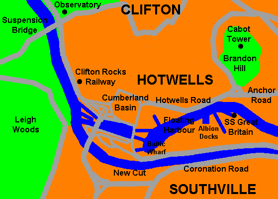
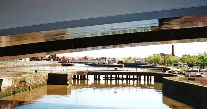
Hotwells from Clifton Suspension Bridge
The image above shows some of the buildings discussed on these pages. The main road is the A4 or Portway which runs from Bristol to the industrial complex and port at Avonmouth. The old wharfs for the White Funnel ferries and Campbell Steamers fare on the river side of the road. From the cliff-face in the bottom left of the picture can be seen the the entrance to the old Clifton Rocks Railway. Between that and the white wall is the lower entrance to the Zig Zag which leads up to Clifton. Just beyond that can be seen the curving frontage of The Colonade, standing where the pump rooms used to be.
As the road curves to the left, on the riverside is where the bust of Samuel Plimsoll is situated. Beyond that can be seen the first of the lock gates leading into the Floating Harbour. Beyond and above the lock gates is the Cumberland Basin road system and its swing bridge. Beyond that are the massive, red brick bonded warehouses. These were built between 1905 and 1919 and used to store tobacco. The tobacco had not yet had customs duty imposed on it and so these warehouses were bonded to the Customs and Excise. The leftmost warehouse is named "B" and is now the home of the Bristol Records Office. The other two are used as storage facilities.
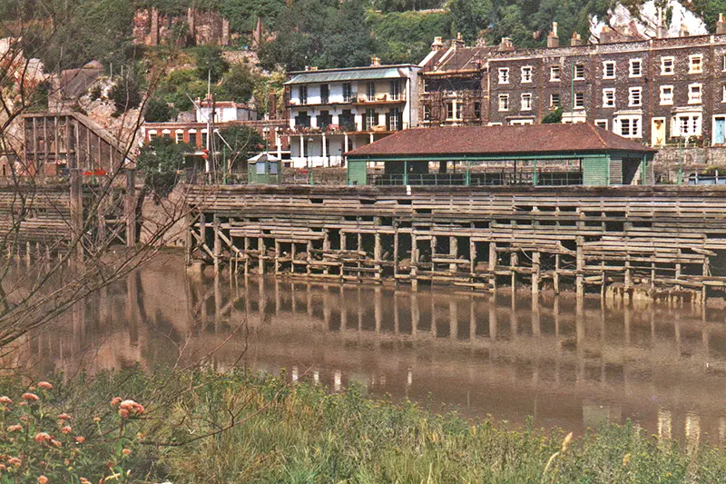
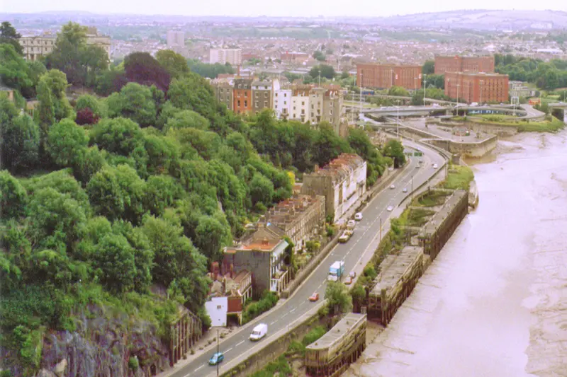
Hotwells wharf, White Funnel ferries and Campbell Steamers used to dock here taking people on trips up and down the Bristol Channel
The entrance to the old Clifton Rocks Railway can be seen on the left


More pictures of the old Hotwells wharves
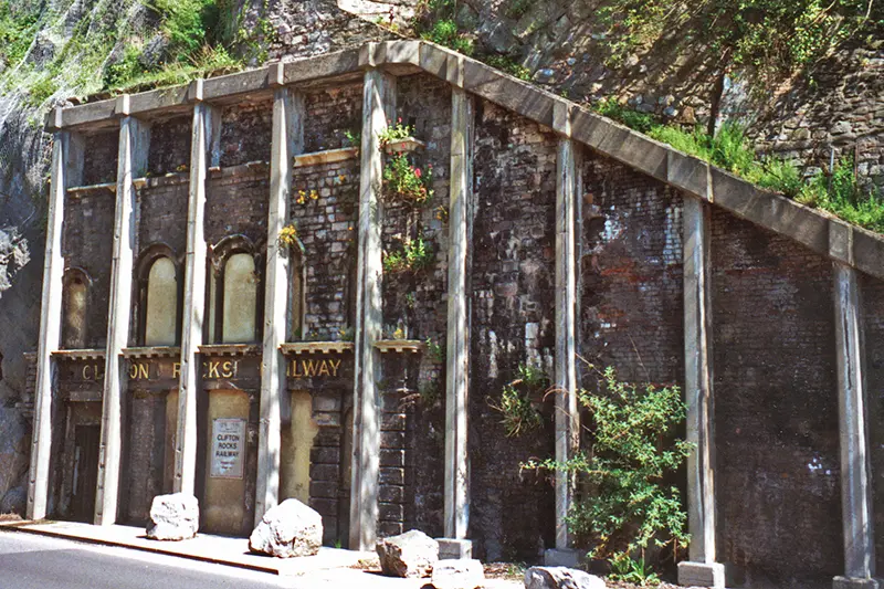
The Clifton Rocks Railway entrance at Hotwells
The funicular railway was closed many years ago with the last train running on September 29, 1934, but it was used as a bombproof studio for the BBC (British Broadcasting Corporation) and as safe storage for the City's archives and art treasures during WWII.
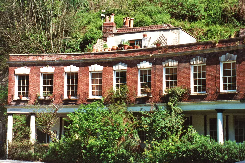
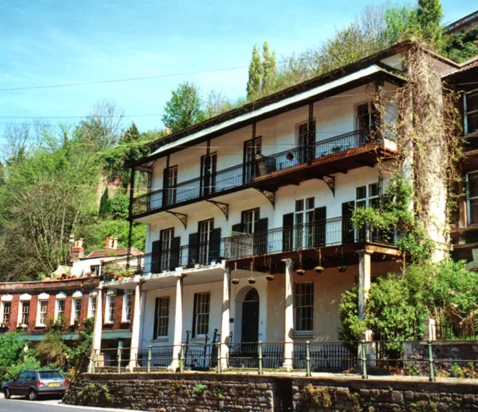
The Colonade was built in 1786 as a shopping arcade and is now private homes
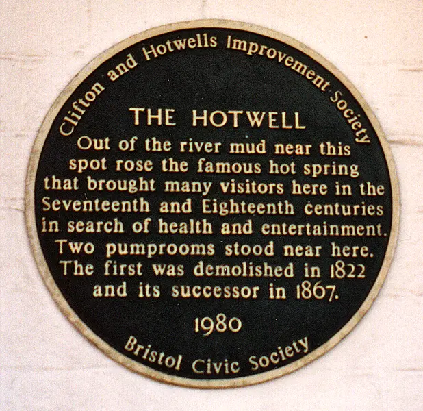
The plaque attached to a wall of the The Colonade
One of the fine houses along the Portway at Hotwells
The Colonade can be seen on the left
Samuel Plimsoll
Walking alongside the river, at the entrance to the City docks, there is a bust of one of the sailors great benefactors, Samuel Plimsoll.
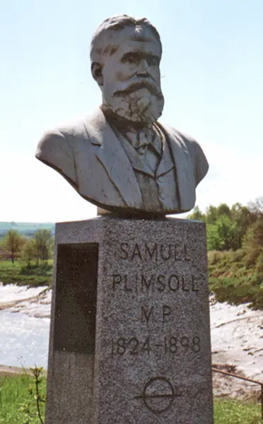
The bust of Samuel Plimsoll
Samuel Plimsoll was born in Colston Parade, next to St Mary Redcliffe church, in 1824. He became the Member of Parliament for Derby in 1868 and campaigned to stop the practice of unscrupulous ship owners of sending grossly overladen or unseaworthy vessels out to sea. They often did this in the knowledge that they would be amply covered by insurance should the ship be lost. His load-line for ships, known as the Plimsoll Line, became part of the Merchant Shipping Act of 1876. Once this act had been passed he resigned from his seat in Parliament but continued to pursue the issues affecting sailors until his death in 1898. This bust, in honour of him, was erected in 1963.
The Floating Harbour
By 1802 the city docks were losing trade and were badly in need of improvement, William Jessop proposed a bold scheme to try and reverse the dock's fortunes. He planned to turn the rivers Frome and Avon into a floating harbour with an area of 70 acres. The amount of work involved was huge. A basin, known as Cumberland Basin had to be dug for the actual docks, lock gates had to be installed at the entrance, a dam had to be built at Totterdown, a channel had to be dug for the Avon around the harbour, this was known as the New Cut, and the Feeder Canal had to be dug from the dam at Totterdown to the River Avon at St Annes. Work began in 1803, and the cost was estimated to be £300,000, but by the time it was finished in 1809 the actual cost was £580,000. This still wasn't enough and in 1865 and in 1870 new, larger locks and wharves had to be installed and the facilities upgraded.
The Floating Harbour from under Cumberland Basin Bridge
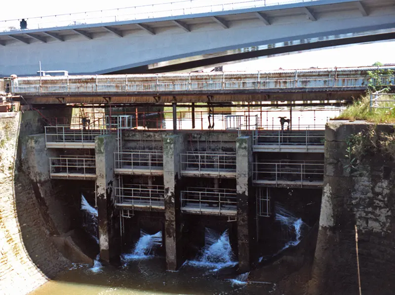
One of the sluices holding back the millions of gallons of water of the Floating Harbour
The reason these sluices and the lock gates are so massive is that the river Avon has the second highest tidal range in the world of 35ft.
The highest tidal ranges in the world are found in the Bay of Fundy in Canada.
The Floating Harbour covers an area of 70 acres - so there is a lot of water. At its deepest point, near Underfall Yard, the harbour is around 33 feet deep. At Cumberland Basin, the water is around 16 feet deep to the sides and around 26 feet deep in the middle. The water gets shallower heading towards the harbourside, averaging around 16 feet. The floating harbour is at its most shallow point at the Feeder Canal, where the water is around 7 feet deep.
When I first wrote this page, I tried to estimate how much water was contained within the Floating Harbour.
Depending on what you read, the Floating Harbour covers an area of somewhere between 70 and 80 acres. An acre contains 43,560 square feet. Now suppose that only half of the area is actually water, the rest are docks, wharves etc. Lets say a total water area of 40 acres. That's 1,742,400 square feet of water area. The harbour has a depth of around 20ft, thats 34,848,000 cubic feet of water. Each cubic foot fo water contains 7.48 gallons of water. So, the Floating Harbour contains 260,663,040 gallons of water. Not very scientific, but it's the best I can come up with.
Once you reach this point of the river, if you look back there is a magnificent view of the gorge.
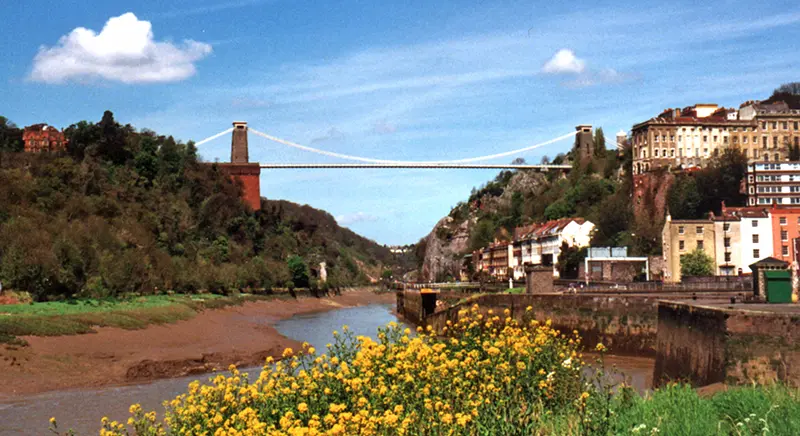
The Avon Gorge from Cumberland Basin
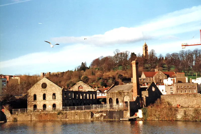
The old gas works at Hotwells
The gas works was founded by the Bristol and Clifton Oil Gas Company in 1824 to produce gas from oil, mainly whale oil. The works expanded and the buildings which can be seen on the site today date to the 1870s. I believe that after a lot of cleaning up because the ground was heavily contaminated some of the original buildings were kept and turned into flats.


More pictures of the old Hotwells Gas Works
In April 2005, Maureen Asked about Allen's Court, Hotwells. She said that " I believe it was demolished in the 1930's it was a small court off Hotwells Road in Bristol although it was well past it's sell by date, my mother was brought up there. Unfortunately, I cannot find any photographs or maps showing me exactly where it was I am tracing my family history at the moment and Hotwells seems to be where they were centred."
I am grateful to Nigel Valentine who sent a scan of a map showing where Allen Court was. It was just along from Clifton Vale and Ambra Vale. Long gone, the area is now student housing.
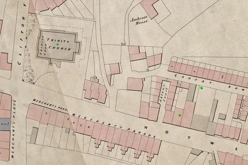
Where Allen's Court was
This is part of Ashmead's 1855 map which is available on Know Your Place
Allen's Court did have an inhabitant who beaome famous. George Wolfe (1834-1883) was an artist known for his atmospheric coastal and landscape paintings. George Wolfe was born in Clifton, Bristol, on January 11, 1834, the son of Charles Wolfe, a boat builder, and Ann, a dressmaker. He was baptised in Bristol on February 23 of the same year, and spent his early childhood years at Allens Court, Hotwell Road, with his two younger brothers, Charles and henry, and younger sister, Louisa. By the age of 17 in 1851, Wolfe had moved to 9 Windsor Terrace in Clifton.
Another family that lived in Allen's Court in 1901 were the Hopkins. George Clifford Hopkins born about 1864, Wife Sarah Ann nee Blackwell (1864 - 1938) and children Lydia known as Blanche (1892-1920), George (1895 -1910), William (1899 - 1976), Lily (1898- 1919) and Georgina.
This page created May 5, 2000; last modified April 28, 2023


