The original city was built on the flat areas between the Rivers Avon and Frome. It has since grown to encompass the surrounding hills, which incidentally protect us from the worst of the weather. Summer Hill in Totterdown is one of the steepest roads in the UK. When I was a child one of my Aunt's lived part way down this road, and our
visits to her in the wintertime always meant hanging on the walls and railings to stop from sliding down the hill.
To the South lay the hills of Dundry, then the Mendip Hills. To the East the River Avon flows on to Bath. The ground rises again to the North of the city, but to the West the Avon cuts its way through the limestone of the Avon Gorge on its way to the Bristol Channel some six miles away.

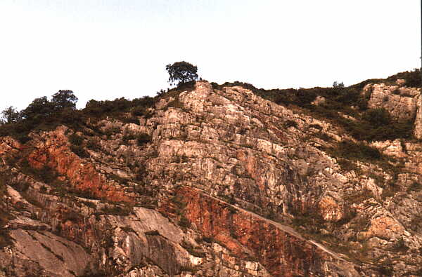
The Avon Gorge from the top of Black Rocks.
In the distance you can see the industrial complex of Avonmouth ~ about 6 miles away. The hills in the far distance are across the Bristol Channel, in Wales.
There was a quarry at Black Rocks where "Bristol Diamonds", a type of quartz, were once mined. Two thousand of them were presented to King James I (1603 - 1625) as decorations.
Millions of years ago, when this part of the British Isles was under the sea a thick layer of Limestone was laid on top of red Sandstone. Other deposits were laid on top of the Limestone. Then came a period of great upheaval and an 'upfold' was formed. The top of this upfold was gradually eroded away.
Around 8,000 BC the last of the glaciers in what was to become Britain disappeared and around 3,000 years later (5,000 BC) Britain became an island when the melting ice sheets severed the land connection with the rest of mainland Europe.
The Avon, when young wasn't the slow moving tidal stream it is now but a powerful torrent that would not be stopped by the outcrop of limestone. The river gradually wore away at the rock eventually forming the 300 feet deep gorge that is the seaward entrance to the city.
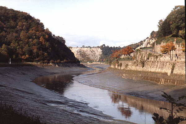
The Avon Gorge
That's the (almost) scientific progression - the REAL reason is far more romantic . . .
Long ago, when the world was young, it was inhabited by a race of giants. Living in the area that would become Bristol were two brothers, Goram and Vincent. Vincent was industrious and hard-working whilst his brother was gluttonous and lazy.
Goram suggested that they build a huge mound of rocks and bones as a lasting monument to themselves. Vincent should provide the rocks whilst Goram would provide the bones from his feasting.
Vincent refused but suggested that they build a wonderful channel for a river. Vincent started on his project and was progressing well, whilst Goram watched. It became evident to Goram that his brothers name would live forever whilst his would be forgotten so he decided to build a rival gorge about three miles from Vincents.
Being a lazy fellow he had no pickaxe of his own so borrowed Vincents. The first thing Goram did was to hew a chair for himself so that he may rest from his labours.
In order that they both share the pickaxe the brothers arranged that they should a shout a warning to eachother then throw the pickaxe the three miles between them. This worked well until one day Goram fell asleep in his chair. Vincent shouted a warning and hurled his pickaxe.
Goram, fast asleep, never heard the warning and the result was that the pickaxe hit him in the head and split his skull, killing him. Vincent was filled with remorse and worked even harder. The channel that we know today as the Avon Gorge was soon finished. But, Vincent could still not rest easy. According to the legend he then formed the stone circle at Stanton Drew, then built another at Stonehenge. Still not having felt he had attoned for his brothers death he swam to Ireland and built the Giant's Causeway.
By now Vincent was worn out through his labours and he returned home to spend the last few hours of his life sat upon the rocks of his gorge.
If you think this is a bit fanciful, then think on the fact that the stone circles at Stanton Drew and Stonehenge still exist, as does the Giant's Causeway. Also, if the legend isn't true, why should the resting place of Vincent still be called Vincent Rocks? The chair that Goram cut for himself is still there in the grounds of Blaise Castle, as is the Giant's Soapdish.
Vincent's Rocks ~ the resting place of the giant, Vincent
There is another legend concerning the fate of the giants. Goram and Vincent both fell in love with the beautiful Avona. To decide which was to marry her they were given the task of draining a huge lake. Goram fell asleep during the task and Vincent won the hand of the fair lady. Goram, broken hearted, threw hmself into the River Severn
and drowned. Today, the River Avon is named after Avona and the remains of Goram's head and shoulder can be seen as the islands Steep Holm and Flat Holm in the Severn.
If you think that the legends of Goram and Vincent are a bit fanciful then you haven't heard the one about the two British kings that built Bristol. A long time ago there lived a king, Malmutius and his queen, Conwenna. These had two sons, Brennus and Belinus. On Malmutius's death the kingdom was split, Brennus got the north of the country, Belinus the south. Brennus was furious as the north was harsh and mountainous, whilst Belinius had the fertile south. They raised armies and were ready to do battle when their mother, Conwenna, suggested that the share the whole of the kingdom between them. This they agreed to do, Brennus came south and built "the place of the bridge", our very own Bristol. According to the legend the Romans knew the settlement between the rivers Avon and Frome as Caer Bren or the "City of Brennus". If you don't believe me then you can go and look at their statues for yourself. They are built into the wall either side of arch of St. John's Gate
in Broad Street. There is a bit of a problem with these statues though as they both carry crucifixes, but they are supposed to have lived a long time before Christ.
There is little evidence remaining of prehistoric sites in Bristol. There is one from the Neolithic period (3,500 - 1,800 B.C.) that exists in the garden of a house called "Cromlech" which is on Druid Hill near the junction of Druid Stoke Avenue in Druid Stoke.
A Bronze Age (1,800 - 500 B.C.) round barrow can be seen in what was known as Milltut Field in Southmead. This is now in the area bounded by Greystoke Avenue, Doncaster Road and Bowness Gardens. The mound is about 60 ft in diameter and about 7ft tall. At one time it may have been used as the foundation for a windmill.
Before the Romans arrived the original Britons lived in tribes. The Dobunni lived in the Bristol area and the area now covered by north Somerset, Gloucestershire and west Wiltshire. The Durotriges had their northern limit at Bristol and lived in the area now covered by south Somerset, Dorset and Wiltshire. These tribes built forts made up of a ditch, a bank and then a wall or palisade. Several of these earthworks can still be found in and around Bristol. Both tribes made coins from which some of their history can be gleaned. The Dobunni appear to have readily submitted to the Romans but the Durotriges fought for a while before becoming subdued.
These Iron Age (500 B.C. - 43 A.D) tribes had several hill forts, the remains of which can be seen in several places such as Blaise Castle which covers an area of about 6 acres. There are three hill forts along the river Avon, Burwalls (or Burgh Walls) now lamost completely gone, Stokeleigh in Leigh Woods which covers an area of roughly 6 acres, and Clifton Down. The first two are on the south side of the Avon. The Clifton Down site is in the area of the observatory, which actually within this camp which covered an area of around 3 acres. The Romano-British field system can also be discerned in the area.
There is the remains of a hill fort at Kings Weston Hill . It was excavated in 1956 by P. A. Rahtz who found evidence of a battle and who concluded the occupants had been wiped out by a group from Blaise Castle using sling-shots. There are also three small round barrows near the site.
Other examples can be seen in the pre-christian burial mounds at Kings Weston and Lockleaze. There is also evidence of early settlement at Portbury, Winterbourne and Oldland Common.
There is also the remains of Iron Age settlement at Ashton Park but most of this is still underground.
I've produced a Google map showing these prehistoric sites as well as others in the Bristol, Mendip and Cotswold regions of Somerset and Gloucestershire - Prehistoric Sites in the Bristol Region.
The map was prepared using information from several sources, especially Leslie V. Grinsell's "Prehistoric Sites in the Mendip, South Cotswold and Bristol Region" published in 1966 by the Bristol Archaeological Research Group and Discovering Regional Archaeology: Southwestern England also by Leslie V. Grinsell and published by Shire Publications. The converter by Movable Type Scripts was used to convert British National Grid coordinates to WGS84 coordinates which is used by Google maps. One the best websites that covers these ancient sites is The Modern Antiquarian site which also covers a great deal of Europe and Scandinavia.
The Romans arrived around 55 BC, peacefully at first, they invaded in force around 40 AD. They set up a major town at Aquae Sulis - now called Bath - 15 miles to the East of Bristol. They had a lot of trouble living peacably with the Celts in Wales, Scotland and Cornwall and built a series of forts on the Welsh side of the Bristol Channel. As such they didn't settle in great numbers in the area of Bristol. What they needed was somewhere within reach of the forts in Wales to resupply them, so they built a harbour at Abona - what is now Sea Mills.
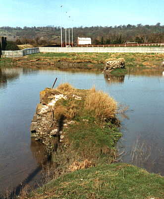
The old harbour at Sea Mills
These are not the original Roman walls but were built later
Although they didn't build a large town here, there are Roman villas and farmsteads all over the area. The main ones seeming to be at Brislington, which was found in 1899 when Winchester Road was being built, and Somerdale. As a matter of fact, I lived about 5 minutes walk away from the site in Brislington. Although some of the courtyard tiles and other artifacts are now in the City Museum there is nothing to even suggest what is buried under some of the houses in Winchester Road. The Roman villa is believed to have burned down in around 367AD. Blaise Castle is also the site of a Roman temple.
This page created January 15, 2000, last modified June 19, 2022