The Tornadoes and Floods
of 1913
This section of the website was started because of my hobby of collecting Terre Haute postcards. Whilst collecting these postcards there were several scenes of the after effects of the tornado of March 1913. Doing some research on this storm I found it was part of a much larger natural disaster and these pages are the result of that.
There are two main sections. This section looks at the weather between January and March 1913 over a great deal of the United States and includes how it affected communities along with a look at why so many bridges failed. The other section is a collection of postcards of the floods and tornadoes.
Introduction
1913 started out much the same as any other year. January saw the introduction of parcel post. In February, Congress ratified the 16th Amendment which streamlined the federal income tax system, New York's Grand Central Terminal weas opened and prizes were put in Cracker Jack popcorn boxes. On March 4th, Woodrow Wilson was inaugurated as the 28th President. Gideon Sundback was finishing the design of the zipper which he patented in April and Henry Ford was perfecting the production line which was introduced in its full form in August.
1913 also saw one of the worst natural disasters that the United States has ever seen. Unlike the 2008 midwest floods that killed 13 people and caused $6 billion worth of damage there are no national statistics, that I could find, of the tornadoes and floods that hit the entire midwest from Nebraska to New York and from Michigan down to Tennessee, over the Easter weekend of 1913. From what I've read, I would estimate that over 1,000 people lost their lives, over a quarter of a million people were made homeless and the damage done would be roughly equivilent, in today's dollars, to the cost of the 2008 floods.
Uusually referred to as the Great Dayton Flood rather than something like the Great Midwest Flood this is more of a historical accident. Dayton being a larger town than most of the affected communities wasn't completely isolated by the loss of a single or even several telegraph wires, it was also one of the first communites to ask for help from the federal government and to send details of the damage it had sustained.
Among the tales of tragedy, death, flood, fire and destruction there are stories of true heroes, people worked who selflessly to save others less fortunate. People who risked their lives, and sometimes lost it, rescuing others. There are also tales of the bottom-feeders of society, from plain selfish people to looters, profiteers and people who stole from the dead.
Map of the United States
The winter of 1913 was unusually warm and wet, almost spring-like, for most of the United States because of a huge high pressure area that had built up over Ontario in Canada. The wet winter had already saturated the soil in the areas that were going to be flooded in March. On Maundy Thursday, March 20, 1913, the area of high pressure over Ontario started to move east and temperatures throughout the midwest plunged to below freezing. The change in temperature was sudden and unexpected, some places reported a more than 40 degree drop in 4 hours - from 60F to 20F. In The already water saturated ground was frozen solid. Along with the drop in temperature came very high winds, hurricane force winds in excess of 70mph were reported from Minnesota, Wisconsin and Michigan all the way down to Mississippi to Alabama.
Winter 1912/13 Weather Reports
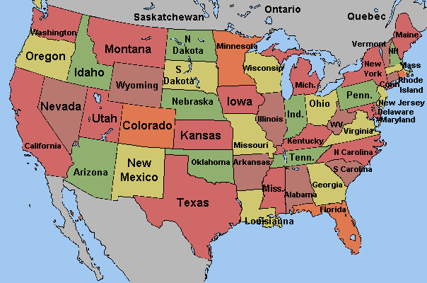
These pages rely heavily on documents provided by the National Oceanic and Atmospheric Adminstration (NOAA), especially their scanned collection of the Monthly Weather Review which covers July 1872 to the end of 1973 in both PDF and TXT formats. When these pages were originally written the older copies of the MWR were hel on the NOAA site but are now accesses through the American Meteorological Society website. The MWR is still published but requires a subscription to access copies from January 2010 onwards. At the time these pages cover the United States was split into 12 districts, each covering major watersheds and not conforming to state boundaries. Each district would compile monthly detailed reports from the weather stations they were responsible for and it these documents I have primarily used to gather the metrological data for these pages.
US Weather Reporting Districts
Map created from Monthly Weather Review Volume 41 (1913): Issue 1 (Jan 1913)
| District | Name | States |
|---|---|---|
| 1 | North Atlantic States | Connecticut, Delaware, District of Columbia, Maine, Maryland, Massacheusetts, New Hampshire, New Jersey, New York, Pennsylvania, Rhode Island, Vermont, Virginia, West Virgina |
| 2 | South Atlantic and East Gulf States | Alabama, Florida, Georgia, Mississippi, North Carolina, South Carolina, Virginia |
| 3 | Ohio Valley | Alabama, Georgia, Illinois, Indiana, Kentucky, Maryland, New York, North Carolina, Ohio, Pennsylvania, Tennessee, Virginia, West Virginia |
| 4 | The Lakes | Illinois, Indiana, Michigan, Minnesota, New York, Ohio, Pennsylvania, Vermont, Wisconsin |
| 5 | Upper Mississippi Valley | Illinois, Indiana, Iowa, Minnesota, Missouri, North Dakota, South Dakota, Wisconsin |
| 6 | Missouri Valley | Colorado, Iowa, Kansas, Minnesota, Missouri, Montana, Nebraska, North Dakota, South Dakota, Wyoming |
| 7 | Lower Mississippi Valley | Arkansas, Colorado, Kansas, Kentucky, Louisiana, Mississippi, Missouri, New Mexico, Oklahoma, Tennessee, Texas |
| 8 | Texas and Rio Grande Valley | Colorado, New Mexico, Texas |
| 9 | Colorado Valley | Arizona, Colorado, Nevada, New Mexico, Utah, Wyoming |
| 10 | Great Basin | California, Idaho, Nevada, Oregon, Utah, Wyoming |
| 11 | California | California, Oregon |
| 12 | Columbia Valley | Idaho, Montana, Nevada, Oregon, Utah, Washington, Wyoming |
Without the warnings given by the various reporting station and telegraphed to various population centers and the newspapers the loss of life and damage done would probably been far greater than it otherwise would have been.
Whilst going through the MWR scans I OCR'd some of the monthly average state temperature and rainfall data and this is available as an Excel spreadsheet.
January Floods
January 1913 was exceptionally warm over most of the midwest, especially in the Ohio Valley district. It wasn't that record high temperatures were reached, just that the average temperatures were higher and in no place in the Ohio Valley did the temperature drop to freezing for more than 24 hours. In New York state, for example, the average temperature was 34F, 10F higher than the normal January temperature of 24F. On 17th January, it reached 68F at Cobden in southern Illinois. It was also exceptionally wet. In Cairo, Illinois, 11.65 inches of rain were recorded for the month and over most of Kentucky 11.4 inches of rain fell in January - three times the normal amount of 3.7 inches and one quarter of the usual amount for the entire year. Incidentaly, a slight earthquake was recorded in Cairo, Illinois on 29th January sometime between 4am and 5am.
All this water meant that most of the major rivers and their tributaries in the Ohio Valley district overflowed their banks for at least part of the time between the 8th and 25th of January. The Ohio River flooded along most of its length as well as most of its tributaries. The same thing happened to the Green River in Kentucky, as well as the Cumberland and Tennessee Rivers also in Kentucky and Tennessee and the lower reaches of the Wabash and White Rivers in Indiana and Illinois. The overflowing of these rivers resulted in flooding in Pittsburgh, Pennsylvania, where one person was drowned; Parkersburg, West Virginia; Cincinnati and Columbus in Ohio. In Columbus a grocer and his horse were drowned when his wagon was swept away. At nearby Mineral City four more horses were drowned and their riders were lucky to survive.
In northern Indiana the Maumee River overflowed its banks and parts of Fort Wayne were flooded. On the lower Wabash River, Logansport, Attica, Terre Haute, Evansville and Mount Carmel suffered flooding and the overflowing of the White River meant that parts of Indianapolis and Elliston were also flooded. Around the vinicinty of Mount Carmel the Wabash River flooded areas 7 to 15 miles either side of the river.
The overflowing of the Cumberland River caused flooding to Nashville and Clarkesville, Tennessee. The flooding of the Cumberland caused an unusal accident at Cumberland City, Tennessee. A train of the Louisville and Nashville Railroad collided with, and severely damaged, a steamboat!
The Kentucky River also overflowed causing extensive flooding especially around High Bridge and Frankfort, both places reported extensive landslides along the steep river banks. Many bridges were swept away by the flood water. Large areas of low-lying land in Kentucky were flooded when the Green River, so much so that the Monthly Weather Report described parts of the state as "vast inlands seas".
Seventy-eight families had to be evacuated from their homes in Madison, Indiana on 12th January when the Ohio River flooded but the next day, on the 13th, 1,700 families were made homeless due to further flooding.
When the Green River in Kentucky flooded an area 5 miles in width over part of its length, somewhere between 2,000 and 3,000 in Calhoun people were made homeless. Forty people took refuge in a house on a low knoll, they were there for two days before they were discovered and rescued. Another 50 people took shelter in a schoolhouse. At Ashbyburg, 1,000 people were surrounded by between 2 and 5 miles of water for several days. At Greensburg, the river reached the highest level it ever had and some streets were covered in 15 feet of water.
In District 7, the Lower Mississippi Valley, flooding was reported in Arkasas when the Black River and White River south of Batesville overflowed their banks. On January 25th, part of levee, several hundred feet in length, was washed away at Beulah, Mississippi.
The floods receded pretty rapidly in the north but further south, in places such as Evansville in Indiana and Cairo in Georgia the flooding persisted for three weeks or more into February.
Oddly enough Districts 9, 10, and 11; Colorado Valley, Great Basin and California recorded some of the coldest weather since 1898 and many young citrus trees were destroyed by frost and an estimated loss in crop value of at least $15 million (1913 dollars).
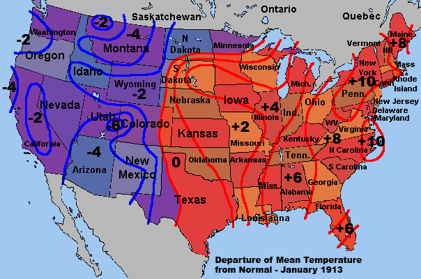
Mean Temperature Deviation from Normal - January 1913
Maps created from Monthly Weather Review Volume 41 (1913): Issue 1 (Jan 1913)
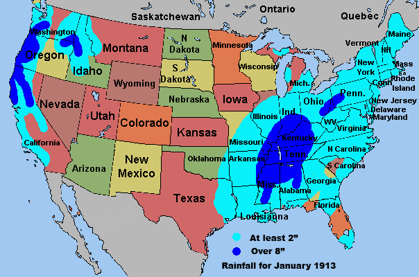
Rainfall for January 1913
Some areas in the center of the dark blue areas had between 10" and 14" of rainfall
| Area | Rivers | Flood Level (feet) |
Crest Level (feet) |
Height above Flood Level (feet) |
Date (Jan) |
Days above flood level |
|---|---|---|---|---|---|---|
| Pittsburgh, PA | Allegheny, Monongahela, Ohio | 22 | 31.3 | 9.3 | 9th | 4 |
| Parkersburg, WV | Ohio, Little Kanawha | 36 | 45.1 | 9.1 | 13th | 8 |
| Cincinnati, OH | Ohio | 50 | 62.2 | 12.2 | 15th | 10 |
| Louisville, KY | Ohio | 28 | 39.5 | 11.5 | 14th | 11 |
| Evansville, IN | Ohio | 35 | 46.7 | 11.7 | 19th | 27 |
| Cairo, GA | Ochlocknee | 45 | 48.9 | 3.9 | 26th | 21 |
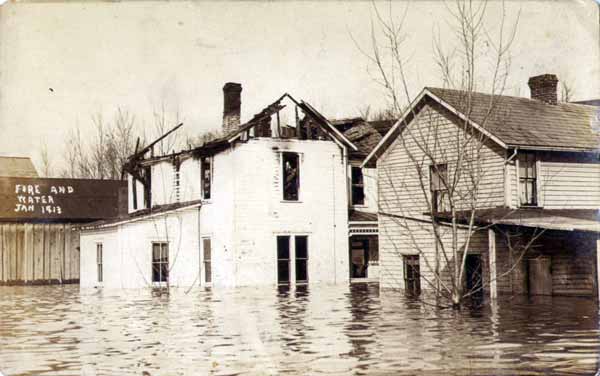
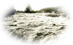
Fire & Flood - January 1913
This postcard, posted in Marietta, Ohio on January 18th, 1913, has no other printed text. Although not printed on the card this is probably a scene from where the postcard was posted - Marietta, Ohio.
Early to Mid March 1913
The floods of January lasted a few days in the northern affected areas and several weeks in the southern but February and March saw more unseasonably warm weather. On 25th March it was 83F in Cumberland, Maryland. On 26th March, it was around 80F in most of Mississippi, Alabama and Georgia by the end of next day the temperature over most of the area had dropped to freezing or below.
The second week of March saw very heavy rain throughout the midwest and northeast and the Gulf States. Western Pennsylvania, New York, Mississippi, Georgia, Alabama and South Carolina all saw the wettest, or close to the wettest, month on record. Highland Home, Alabama received 19.45 inches of rain in March. This was caused principally by the tornado bearing storms of the mid-west and most of the rain fell between 23rd and 27th March.
Flood reports were sent from the entire length of most rivers and waterways in Districts 1 and 2 as roads, bridges, telegraph poles, livestock and buildings were swept away. All these rivers reached record or near record flood levels, the Mohawk River in New York, rose 16 feet in three days.
On the night 15th March, a levee protecting Macon, Georgia collapsed causing flooding to a goods yard, where the freight and even the tracks were damaged. The water rose to a level of about 3 feet in a nearby fertilizer plant and much damage was done there. As well as this damage, a railway trestle was destroyed and another severely damaged.
The Connecticut River at Brattleboro, Vermont on 27th March, saw the water level at the highest it had ever reached before. At Sharon, Pennsylvania a boom that was holding back 3 million feet of cut logs was swept away. The logs did considerable damage as they raced downstream. At White River Junction on the White River the logs struck and destroyed a highway bridge.
| Reporting Station | River | Height above Flood Level (feet) |
Date (March) |
|---|---|---|---|
| Tuscaloosa, AL | Black Warrior | 12.7 | 1st |
| Demopolis, AL | Tombigbee | 15.3 | 15th |
| Chappella, SC | Saluda | 7 | 16th |
| Catawba, SC | Catawba | 8 | 16th |
| Milledeville, GA | Oconee | 8 | 16th |
| Camden, SC | Wateree | 9 | 17th |
| Columbia, SC | Congaree | 8 | 17th |
| Montgomery, AL | Alabama | 13 | 17th |
| Jackson, MS | Pearl | 9 | 18th |
| Selma, AL | Alabama | 14.4 | 19th |
Tornadoes
Alabama had already suffered several tornadoes, one on 2nd March and two on the 13th but others struck on Friday, 21st March. A storm that stretched from northern Texas to western Pennsylvania and New York produced the Alabama tornadoes. One at hit Florence at 1am, it killed three children and destroyed 20 houses. Half an hour later, another tornado struck near Decatur and it's path took it to Meridianville, another 3 people were killed and 20 injured. Other tornadoes smashed into Lower Peachtree and Thomasville, Alabama practically destroying both towns. In Lower Peachtree, 27 were killed, 68 injured and 200 left homeless; at Thomasville, 5 people were killed.
Later that day, a tornado struck Albion in Michigan. This tornado centered on the Albion Malleable Iron Company which it practically destroyed as well as crushing several nearby rail cars.
Easter Sunday, March 23rd, 1913 saw a storm front moving west into Nebraska and Iowa. At around 5pm the first of the 7 tornadoes produced by the storm hit Craig, Nebraska then cut a swathe to Blencoe, Iowa. This tornado didn't kill anyone but injured 13 and destroyed 11 homes.
The second hit Havelock, Nebraska around 5:30pm and moved to Greenwood. Again, no-one was killed but 2 people were injured.
The third touched down in Yutan, Nebraska again around 5:30pm and ended in Logan, Iowa. This tornado killed 22 people, 17 of whom lived in or around Yutan.
The fourth started near Ralston, Nebraska around 5:45pm where 7 people were killed. It then moved northeast into Omaha where a further 94 were killed then onto Beebeetown, Iowa where it killed two children. This tornado killed a total of 103 people, injured 350, destroyed 600 homes and damaged a futher 1,100.
The fifth touched down near Douglas, Nebraska around 6:15pm then moved northeast to Berlin, which is now called Otoe, where it killed 12 people, another person was killed at Rock Cliffs. Moving into Iowa the tornado killed 3 more near Barlett and another 2 near Glenwood. Altogether this tornado killed 18 people and injured a further 100.
The sixth tornado started just south of Bellevue, Nebraska at around 6:15pm then moved northeast into Iowa, hitting Council Bluffs where it killed 17 people, Gilliant, 2 killed; Weston, another 2 casualties, Neola, 3 killed and ending near Harlan where it killed another person. Altogether this tornado killed 25 people and injured 75.
The seventh tornado passed through Pawnee county around 7:00pm, Nebraska, but luckily no dead or injured were reported.
Within 2 hours these tornadoes had killed 177 people, injured 510 and left over 7,000 people homeless in western Nebraska and eastern Iowa.
That evening, at around 9:45pm on Sunday, 23rd March, 1913, a tornado hit Terre Haute, Indiana. In just 2 1/2 minutes, 21 people were killed, 250 people injured and 300 houses destroyed.
On 24th March, 1913 another tornado hit Baroda in Michigan, no-one was killed but several farm houses were damaged. The same day another tornado struck southern Illinois. It came to ground 2 miles west of Makanda and moved northwest towards West Frankfort. A train with 41 cars was hit and 21 of these were derailed. The engineer, Mr. Waggoner, and the fireman, Mr. Andrews, were seriously injured. The tornado wrecked 39 farms and killed three people.
The tornadoes over the Easter weekend killed around 274 people, injured over 1,000 and left around 10,000 homeless.
The Weather 23rd - 27th March 1913
A second wave of rain hit the midwest starting around 23rd March, huge amounts of rain fell over Illinois, Indiana, Ohio and western North Carolina in a swathe 500 miles long and 200 wide. It rained continuously until 27th March over most of this area, and also extended into western Pennsylvania, western New York, Arkansas, Kentucky and Tennessee.
What had happened was that an area of low pressure settled over southeastern Nebraska on Sunday 23rd March. From this area came the heavy rains over states to the east on Monday. The next day, Tuesday, 24th March, the rains over Illinois decreased and even ceased in northern Illinois but continued unabated and even increased over Indiana and Ohio. That evening it was still raining in Illinois, Indiana and Ohio but the downpour had extended along the St. Lawrence Valley into the New England states.
Most rivers in Indiana and Ohio reached flood stages sometime on the 24th March or early 25th March. In Ohio, the Sandusky River flooded to a depth of 11.4 feet at Tiffin and to a depth of 11.5 feet at Fremont. On the evening of the 24th March, the area of low pressure over Nebraska had moved northeast over the Great Lakes and into Canada. As this area of low pressure moved northeast a new low formed that stretched from northern Texas to New England. This second low caused heavy rain between 24th and 27th March from western Pennsylvania to southern Indiana and over northwestern Arkansas. In Illinois, the levee at Vandalia collapsed on the 25th March and 60,000 acres of land were flooded. The Sangamon River, also in Illinois, rose 2" every hour and eventually flooded Petersburg to a depth of several feet forcing many families to abandon their homes and seek shelter elsewhere.
These two areas of activity then joined over western New York and caused heavy rains there on the 26th March. Another low formed over southern Texas on 25th March and this caused heavy rain over eastern Tennessee and Kentucky. All this rain meant that flooding was extensive and most rivers in Ohio, Indiana, Illinois, Kentucky, West Virginia, northeast Arkansas, western Tennessee, western Pennsylvania and western New York flooded.
The Black and White rivers in Arkansas also flooded.
In Districts 1, 6 and 7, North Atlantic States, Missouri Valley and the the Lower Mississippi Valley, the floods had receded by 1st April. In Districts 2, 3, 4 and 5, the South Atlantic and East Gulf States, Ohio Valley, Lake States and Upper Mississippi Valley, the flooding continued into the first week of April.
Here's a partial list of communities that suffered most from the flooding...
| State | Community |
|---|---|
| Arkansas | Helena, Holly Bush, Mounds, Wilson |
| Illinois | Cairo, Carmi, Harrisburg, New Haven, Petersburg, Shawneetown, Vandalia |
| Indiana | Anderson, Attica, Broad Ripple, Bloomington, Bluffton, Brookville (16), Cedar Grove, Connersville, Elkhart, Ellwood, Elnora, Evansville, Fort Wayne (6), Frankfort (2), Hartford City, Howell, Huntington, Indianapolis, Ingleside, Jeffersonville, Kokomo, Lafayette (1), Laurel, Lawrenceburg, Logansport (1), Madison, Marion, Martinsville, Matthews, Metamora, Mount Carmel (1), Mount Vernon, Muncie (1), New Richmond, Newcastle (1), New Trenton, Noblesville, Patriot, Peru (20), Petersburg, Portland, Prenton, Richmond, Robertsville, Rushville (1), Shelburn (1), Shelbyville, Taylorville, Terre Haute (4), Tipton, Upton, Vernon, Wabash, Washington (4), West Terre Haute |
| Kentucky | Bellevue, Bromley, Caseyville, Columbus, Covington, Dayton, Hickman, Ludlow, Newport, Paducah, West Hickman |
| Louisiana | Breaux Bridge |
| Missouri | Anniston, Belmont, Birds Point, Charleston, Crosno, East Prairie, Greenfields Landing, Wyatt |
| New York | Albany, Binghampton, Buffalo, Camillus, Corinth, Dansville, Fort Edward, Fort Plain, Glens Falls, Hadley, Hornell, Luthern, Marcellus, Marietta, Mount Morris, Olean, Port Bryon, Rensselaer, Rochester, Schenectady, Seneca Falls, Troy, Waterloo, Watervliet |
| Ohio | Akron, Bellefontaine, Bellevue, Carey, Carollton, Celina, Chillicothe (18), Cincinnati, Circleville, Cleveland, Cleves (2), Columbus (64), Coshocton, Dayton (150), Defiance, Delaware, Delphos, Dennison, Deshler, Dresden, East Liverpool, Elizabethtown, Findlay, Fletcher, Fostoria, Fremont (14), Galipolis, Girard, Gnadenhutten, Hamilton (50), Harrison (12), Hartwell, Ironton, Ivorydale, Larue, Lebanon, Lima, Lockland, Lockport, Londonville, Loveland, Lowell, Malta, Marietta, Massillon (5), McConnelsville, Miamisburg (50), Middletown (14), Millersburg, Moscow, Mount Vernon, New Bethlehem (2), New Philadelphia, Newcomerstown, Omega, Ottawa, Piqua (13), Port Washington, Portsmouth, Prospect, Sidney, Springfield, Steubenville, Stratford, Tiffin (18), Toledo, Troy (9), Unionville (Pinchtown), Urichsville, Valley Junction (6), Wellesville, West Liberty, Woodsdale, Youngstown, Zanesville (10) |
| Pennsylvania | Beaver Falls, Columbia, Dickson City, Edwardsville, Fallston, Franklin, Kingston, Marietta, Meadville, New Brighton, Mahoningtown, Newcastle, Oil City, Pittsburgh, Pittsfield, Rochester, Scranton, Shamokin, Sharon, Titusville, Warren, Westmoor, West Nanticoke, Youngstown |
| Tennessee | Memphis |
| Vermont | Springfield |
| Virginia | Scottsville |
| West Virginia | New Martinsville, Parkersburg, Riverside, Wheeling |
The numbers in brackets are the number of dead.
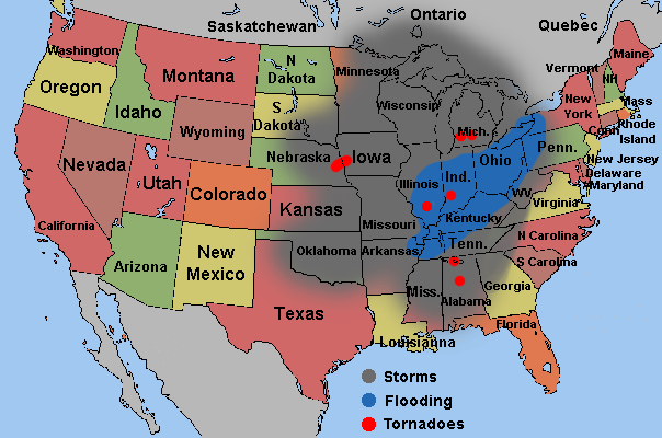
The Affected Area of March 1913
Tales of the Great Flood of 1913
Although there was torrential rain throughout the midwest the whole nation's attention was on the news coming out of the series of tornadoes that had ripped through eastern Nebraska and western Iowa, especially Omaha in Nebraska where a tornado had smashed its way from the southwest to the northeast of the city on Sunday, 23rd March. Ernest Percy Bicknell, National Director of Civilian Relief of the American Red Cross in Washington D.C. ordered the delivery of aid to the stricken area. The government also ordered the army and National Guard to the area to render aid. The following Tuesday, 25th March, Bicknell was en route to personally oversee the relief of the city. It was then then he got news that Indiana, Ohio and Kentucky were suffering from severe flooding. Samuel Moffett Ralston, who had only taken office as Governor of Indiana on 13th January, had already ordered a train carload of coffins from Chicago in expectation of the loss of life that was to occur.
As most of the rivers in the midwest generally flow from north to south as water poured into the major rivers communities further north were the ones that suffered first. As the water made its way south almost every community along the major river systems and some of the smaller ones suffered to some extent or other.
Cities further south knew what was coming their way. Once the major river systems such as the Wabash and Ohio flooded they knew all that water was going to eventually drain into the Mississippi River system. On Wednesday, 26th March, when most of Indiana and Ohio was flooded, the Mississippi River Commission sent a directive that all levees under their control were to be raised. This was hard, slow work as the work was done by mule teams and scrappers and was supervised by Major E. M. Markham of the Memphis Engineer District. Three days later, there were 300 teams working in Arkansas raising the levees, especially the ones around Luxora, Osceola, Sans Souci, Pecan Point, and Lamberthville.
Arkansas Governor James Futrell ordered 100 convicts to work on the levees in the Lower St. Francis district in Missouri down to the border with Arkansas. It seems no one wanted to work on the levees, even considering how cold and wet it was, even among those those whose land and homes would be protected by them. Workers were bought in from as far away as St. Louis to work on the Arkansas levees and many negroes were forced to do the work at the point of a gun. What was especially irksome to the engineers was that in some places farmers were plowing them under the land almost as fast as they were being built up.
By Monday, 31st March, just as the flooding in Indiana and Ohio was receding, it was realized that not much more could be done to save the communities in the Mississippi River valley. Around 5pm that evening the levee at Columbus, Kentucky gave way and the town was flooded to a depth of 10ft in places. Within days scores of the levees had collapsed, Greenfields Landing and Birds Point, both in Missouri, on 1st April. The one at Birds Point simply floated away! Thirty eight National Guardsmen had to be rescued from a piece of it, 200 yards long and 10 ft wide, that was making its way down the Mississippi River. West Hickman, Kentucky collapsed on 4th April and the town was flooded to a depth of 15ft. A levee around Memphis was breached on 5th April. On 10th April, 2,900ft of the levee near Wilson, Arkansas was washed away. By the end of April all of the flood water had receded but it had washed away a total 20,000 ft of the levees in the Memphis Engineer District alone.
Timeline
| Date | Event |
|---|---|
| Friday, 21st March | Tornadoes hit Alabama wrecking Decatur, Florence, Lower Peachtree, Meridianville and Thomasville. A tornado also wrecks Albion, Michigan |
| Sunday, 23rd March | Tornadoes hit Nebraska and Iowa, another hits Terre Haute, Indiana. In Nebraska; Bellevue, Berlin (Otoe), Craig, Douglas, Greenwood, Havelock, Omaha, Ralston, Rock Cliffs and Yutan. In Iowa; Barlett Beebeetown, Blencoe, Council Bluffs, Gilliant, Glenwood, Harlan, Logan, Neola and Weston all suffer damage |
| Monday, 24th March | Tornadoes hit Michigan and Illinois. Baroda, Michigan and Makanda and West Frankfort in Illinois damaged. Flooding starts in Ohio and Indiana Logansport Bridge swept away |
| Tuesday, 25th March | Flooding in Akron, Cincinnati, Columbus and Hamilton in Ohio Flooding in Attica, Martinsville, Taylorville and West Terre Haute in Indiana At 11:50am mains water shut off at Middletown, Ohio 12:12pm Black Street Bridge, Hamilton, Ohio collapses 12:28pm High-Main Street Bridge, Hamilton collapses 2:12pm Cincinnati, Hamilton & Indianapolis Railroad bridge, Hamilton collapses Morris Street levee in Indianapolis, Indiana washed away Brown Street Bridge, Lafayette, Indiana collapses Gas and electricity fail at Logansport, Indiana Electricty fails at Hamilton, Ohio Electricty fails at Martinsville, Indiana at 10pm Black Street, High-Main and Railway Bridges collapse at Hamilton 3rd and 6th street bridges at Logansport swept away Railway bridge at Middlestown, Ohio swept away Bridge at Portsmouth, Ohio swept away Logging boom at Sharon, Pennsylvania gives way All bridges bar the railway bridge at Tiffin, Ohio destroyed |
| Wednesday, 26th March | 2:15am Columbia Bridge, Hamilton, Ohio collapses Lakeview Hotel in Hamilton, Ohio collapses Main Street Bridge, Lafayette, Indiana collapses Directive from Mississippi River Commission to strengthen all the levees along the Mississippi Levee protecting west Indianapolis washed away at 10am At least three bridges are swept away in Indianapolis High point of flood at Indianapolis and Fort Wayne, Indiana High point of flood at Tiffin, Ohio Looting reported at Tiffin Levee protecting north Terre Haute, Indiana washed away Columbia Bridge, Hamilton, Ohio collapses Champion Paper Mill, Hamilton, Ohio catches fire 5:30pm - mains water restored to Middletown, Ohio |
| Thursday, 27th March | 8am - gas plant at Terre Haute, Indiana stopped operations 8:45am - electricity generation at Terre Haute stopped Reservoir dam at Akron, Ohio bursts. Cleveland and Akron Bag Company levee in Cleveland, Ohio breached. Railcar of carbide in Dayton, Ohio explodes killing several. 100 Naval reserves arrive in Dayton from Toledo to help rescue work. Martial law declared in Dayton Supplies of food reach Middletown, Ohio Federal troops arrive at Troy, Ohio Work starts strengthening the levees along the Mississippi High point of the flood in Terre Haute, Indiana |
| Friday, 28th March | Flood starts to recede in Dayton Vandalia Railroad Bridge, Indianapolis, Indiana collapses Electricity restored at Terre Haute, Indiana |
| Saturday, 29th March | Levees washed away at Lawrenceburg, Indiana Gas restored at Terre Haute, Indiana |
| Sunday, 30th March, | Dayton pumping station back in operation Secretary of War, Lindley Garrison, tours Hamilton, Ohio Mass funteral of 49 victims at Hamilton Beckett Company paper mill, Hamilton collapses Relief committee formed at Lawrenceburg, Indiana |
| Monday, 31st March | Electricity restored to part of Dayton Flood water recedes in Indianapolis Steamships bring food and supplies to Portsmouth, Ohio |
| Tuesday, 1st April | Levee at Greenfields Landing, Missouri gives way Levee at Birds Point, Missouri simply floats away |
| Friday, 4th April | Mengel Box Company levee is breached at West Hickman, Kentucky |
| Saturday, 5th April | Levee at Memphis, Tennessee collapses |
| Thursday, 10th April | Levee at Wilson, Arkansas washed away |
| Sunday, 13th April | Dinner in Jefferson, Indiana to celebrate the convicts who helped shore up the levees around the town |
| Thursday, 24th April | Ferry "J. K. Cullen" used instead of the Main / High Street Bridge at Hamilton, Ohio |
| Saturday, 26th April | Brown Street Bridge, Lafayette, Indiana reopens |
| 15th June | Champion Paper Mill, Hamilton, Ohio back in production |
| 1914 | Replacement Dresden suspension bridge opens Long Covered Bridge near Metamora, Indiana replaced |
| 1922 | Branch Hill Bridge, Loveland, Ohio replaced by the Blue Bridge after it had collapsed in the 1913 floods |